Pages

Friday, May 6, 2011

Mt. Romelo


Located in Siniloan, Laguna PH, known as Mt. Famy to some. definitely offers an exciting weekend getaway, just a 3 hour trip from manila, making it very accessible.

Mt. Romelo is known for it's waterfalls, the Buruwisan falls, Lanzones falls, Batya-batya falls, Sampaloc falls and the Old buruwisan falls.

The first time i've been here was wayback 2003 from then i keep going back from time to time. Just November 13-14, 2010, me and my colleagues together with some of my friends went here. it's still the same beauty and i hope it will never change.

After our work shift we went to Parklea crossing, Madaluyong city to take a jeepney to Tanay, Rizal.
from Tanay we took another one to Siniloan, Laguna where we bought supplies at the public market, from there board a tricycle bound to Mt. Romelo's Jump-off point for PHP 20.00 per head, often the tricycle drivers will say "Buruwisan!? Buruwisan!?"  after 15 minutes or so we reached the jump-off and crossed a river going to the registration.


We paid a registration fee of PHP 20.00 per head, Locals offer guide services but it's optional. then we started to trek. the trail is not that steep but on rainy season it gets muddy and will make the it difficult.


 After one hour we reached the first hill and rest.


at the top of the first hill


We reached the camsite after and hour and a half. the campsite has a store where you can also buy rice, canned good and other supplies. there's also huts for rent if you don't have any tent, the rate is PHP 200.00+. it's already dar when we arrived so after wee cooked dinner and have a couple of drinks we call it a night to prepare exploring first thing in the morning.

After breakfast we proceed to Buruwisan falls, that is just below the campsite. we took the steep trail going there since it much faster.


Buruwisan falls

Buruwisan

Tarzan max jump

After we dipped in Buruwisan, we went to Batya-batya falls which i think is 30 minutes away from the campsite, We're supposed to go to Sampaloc falls also but the current is Batya-batya is so strong, (the way to Sampaloc falls is actually to climb Batya-batya falls). unfortunately our camera's batteries died which is so frustrating. Here's my photo of the Sampaloc falls back in year 2004, I apologize for the picture's resolution, we don't have our digicam back then hehe.


Sampaloc falls, very similar to Buruwisan
and also at the top of the Old buruwisan, that i think is accessible by rappeling.
Old buruwisan
 We went to Lanzones falls for our last stop, I think it's about 20ft. high and has a small catch basin. i'll be posting picture of Lanzones, Batya-batya and Sampaloc falls when i get back to Mt.romelo again.

 I'll never forget the beauty of this place, i hope it will not change.
-Mt. Romelo, November 13-14, 2010
 How to get to Mt.Romelo
-Board a jeepney bound to Tanay, Rizal at Parklea crossing in Mandaluyong city
-From Tanay take another jeepney to Siniloan,Laguna, at Sinoloan take a tricycle to Mt. Romelo's Jump-off.


Tarak Ridge


Located in Mariveles, Bataan Philippines. it's peak stands 1130+ MASL, this is one of the popular destinations for some mountaineers. it offers a view of the corregidor island and manila bay. The place is beautiful but i don't recommend this to first time climbers, the trail to the ridge is so steep.


At the Jump-off 

This was our first major climb with my friends, we went here on March 26-27, 2011. we board a bus bound to Mariveles, Bataan then get off at Alas-asin.  you can catch these buses at their terminals in Cubao, Quezon city. we left at 8:00am. it took at least 3-4 hours to get to Barangay Alas-asin in Mariveles (Tarak ridge's jump-off point). registration fee is required at the barangay hall for PHP20.00.


We had lunch on this small eatery just across the jump-off

A 30-45 minute walk from the jump-off before we reached the foot of the mountain, wherein we passed a residential area.


Start trek

The trail is not that difficult on the first part of the trek. there are also part of the trail that are not covered by trees so i suggest you bring sunblocks to protect the skin from the sun. on our way we encountered a trail that was destroyed by landslide, it's passable even without any ropes. After 3 hours we reached the Papaya river where we decided to camp then just proceed to the ridge early next morning.


Papaya river


We woke up at 6:00am then proceed to assault the ridge.we got to the ridge after two hours of strenous hike.

View from the campsite at the ridge


Then off we go to El saco peak.


There's a dense mini forest to the summit, also a part where we ducked just to pass through the bushes and small trees. finally we reached the peak, the view was really majestic. it was really worth it. by the way we ran out of drinking water in the ridge and summit. it is important that each person brings at least 2-3 liters of drinking water to be well hydrated.


At the peak


Tarak ridge
Mariveles, Bataan PH
- March 26-27, 2011


How to get to Tarak ridge

From Cubao, Quezon city  PH, board a bus bound to Mariveles, Bataan from five star bus terminal or any other terminals that offers the same trip.

Get off at Alas-asin from here register at the barangay hall, prepare a PHP20.00 registration fee.

* Going back to Manila, From Alas-asin, take a bus back to Cubao.
- Locals said that the last trip for the buses that passes by Alas-asin is at 5pm.


Saturday, April 30, 2011

Daraitan


Located within the boundary of Tanay, Rizal and General Nakar, Quezon province. a small town known for its clean rivers. It offers many outdoor activities, there are Mountains to climb, caves to explore and the river i for kayaking, rafting and water trekking. Daraitan is definitely a hidden paradise that is yet to be explored.

We went here last January 29-30, 2011 for a friend's two day birthday celebration. Going to Daraitan takes about 4-5 hours at least. from Parklea at Crossing, Mandaluyong city Philippines. we're supposed to take a jeepney to Tanay market then from there board another to Daraitan which is the usual way getting there.
Luckily we were offered a trip straight to Daraitan for PHP 100.00 per head, (We were 21 by the way).

We left Parklea at around 12:30pm, after two hours we reached Tanay market  were we stopped for a while to buy supplies. on our way now to Daraitan some of us rode at the top of the jeepney including me, it was fun.


The bridge to barangay Daraitan


We reached Daraitan at around 5:00pm, we were also asked for a registration fee of PHP 10.00 per person.
the locals offered guide service but we chose not to get one even though this is all our first time here, just to spice up more adventure on our trek not knowing where should we go.the trail is straight forward its just that it rained making the trail muddy and slippery. after an hour walking in darkness we reached an area where we can set up a camp, it can accommodate at least 5-8 tents. after dinner and a couple of drinks we slept.


View from where we camped

My friends began exploring first thing in the morning, i was too sleepy to come so i don't have any pictures of me of the places they've been.
here are some pics,


After we had our lunch we started swimming, the water is clear and cold. i tried going to the middle and i was surprised that the water was just below my chest, there were many rocks under that you can step on but still you have to be careful, your feet may be stuck between some rocks. there are spots that the current are strong. given that the water's  cold and it's windy we didn't feel the heat of the sun but still after we finished swimming some of us got sun burned.


We head back to Manila at around 5pm, and we still rode on the top of the Jeepney. we got to Manila at 9pm.I wasn't able to upload more photos of this place because my camera's memory card got corrupted.


I'm looking forward to go back to Daraitan to explore more of it.
- Daraitan January 29-30, 2011


How to get to Daraitan,


From Parklea in Crossing, Mandaluyong city, Take a jeepney to Tanay
Then from Tanay Market take another jeepney to Daraitan

* Prepare a PHP10.00 registration fee at Daraitan's barangay hall.

Tuesday, April 26, 2011

Pico de loro


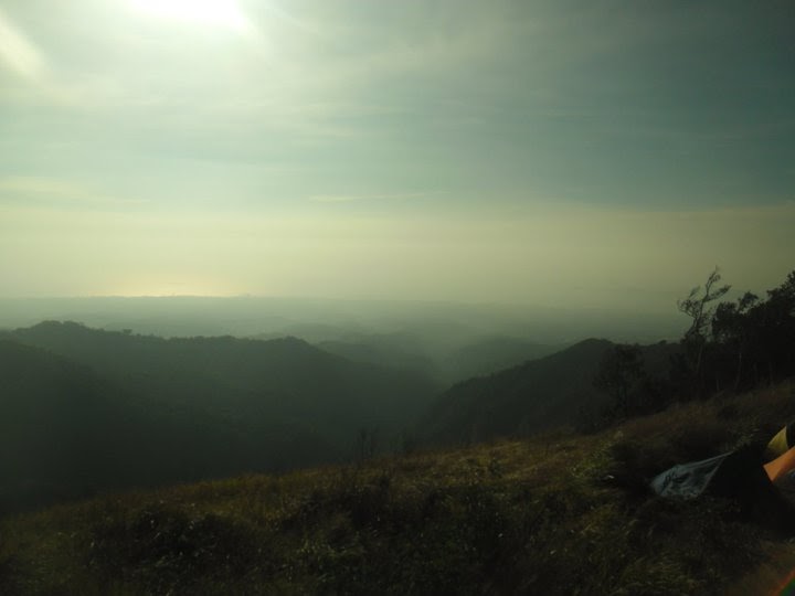
 Summit's view from the campsite

Mt. Palay-Palay a.k.a Pico de loro Located approximately 85 kilometers southwest from Manila,not a bad destination for a weekend getaway. getting here takes just about three hours. Me and my friends usually go to Mt. Romelo but we since we've been there for almost 10 times so we decided to try a different one. on our way here we didn't go to any bus terminals, we were told that we can just catch a bus in Baclaran, just in front of the Baclaran church to be exact.

In the bus off to Ternate


After almost three hours we've reached Ternate, Cavite. We went to the market to buy food, water and last but not the least is liquor haha. then off we go to the jump-off located in the magnetic hill. on our way there we passed a bridge that offers a good view of the river and sea, locals here said that salt water and fresh water mixes here.
here's the picture,

 Right side view from the bridge if you're bound to the magnetic hill

Left side view from the bridge if you're bound to the magnetic hill


We just took a tricycle (trike) to get to the DENR (Department of Environment and Natural Resources) station where we need to register first. there are many tricycles in Ternate that proactively offers to take you to DENR even stopping by to a market to buy supplies. they also give their contact numbers so they can be contacted to take us back to Ternate after our hike.

Tricycle


Road to Magnetic hill

After almost twenty minutes we reached the DENR station, registered first before we climb, we paid P10.00 for registration fee. we now then distributed the weight of our supplies in each of our bag then head on to the jump-off point which is i think 100+ meters away from DENR station.

Jump-off point, just on the side of the road.


The trail is straight forward so we chose not to have a guide. after almost an hour hiking we reached the base camp 1 which is a nipa hut that we also need to pay a registration fee of P10.00 or i think maybe a donation for the family that lives on that hut, since they help maintaining the cleanliness of the place and manages garbage disposal for our convenience. You can also buy cold softdrinks here. there's also a water source for us to fill up our individual water containers.

We continued hiking then after about 45 minutes we passed by a small wooded gate that leads to a trail that is divided but not to worry since there's a sign that shows the way to summit.

To Pico de loro

The left trail leads to a waterfall then the right trail leads to the summit. its already 4:30pm when we reached this sign board so we decided to camp near the waterfall then will proceed to the summit first thing in the morning.
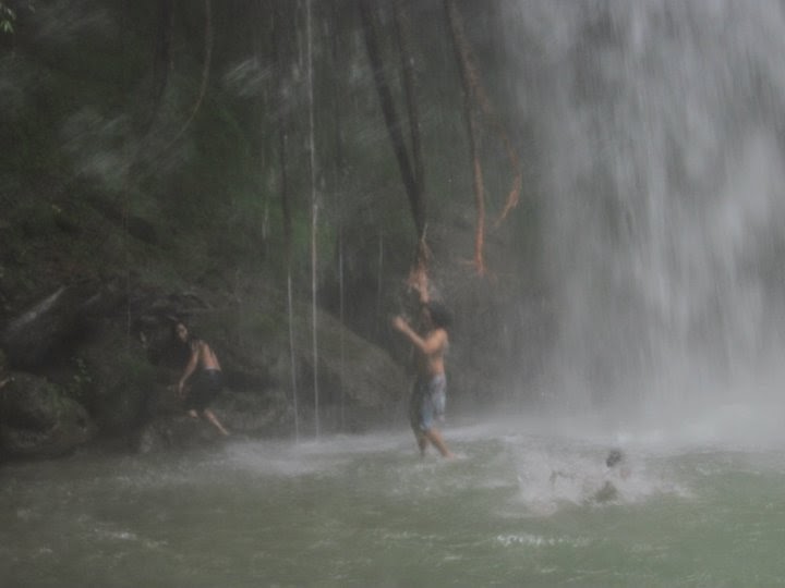
we then pitched our tents and went to the waterfall to get water and freshen up. The trail to the waterfall is steep and very similar to the steep trail going to Buruwisan falls in Mt. Romelo. The waterfalls would be much better to visit on a rainy season.

This is located before you get to the waterfalls


Refreshing cold water!

After we freshen up, we head back to our camp then cooked our food then finally drinking session under the moonlight with cold winds hahaha. We slept at around 1:00am then woke up at 7:00am, we cooked breakfast then prepared ourselves to assault the mountain's summit. the trail to summit is steep.i forgot how many times we took a rest, some parts of the trail is about 60 degrees that we cling to roots and rocks to climb. it's really important to have at least 3 liters of water for each person us to keep well hydrated. the picture below is the only one i got of the trail. I got so tired and  forgot to take pictures.

Tired and excited :)
It took us at least two hours or more to reach the campsite near the summit from where we camped. there's this field that has a lot of bamboos, it almost looked like a panda's natural habitat.

:
Thrilled  :)


here's some pictures of us at the campsite,

Near a cliff


Same cliff :p

at the edge


Then off we go to the summit, it's just 10-15 minutes away from the campsite. it's a good thing that the weather on this day is on our side, if not we probably encountered much difficulty assaulting the summit. the trail has loose rock that we still did hold on to grass and some roots to maintain balance.

On our way to the summit

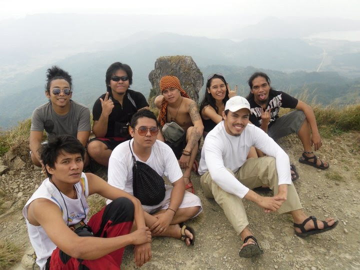
At last the summit, standing 664+ MASL, they said that this is the highest point in Cavite. it gave us a fascinating 360 degree view where in you can see Cavite, Batangas (Nasugbu) and the South China sea.

The campsite on where we at 15mins ago, viewed from the summit.

Sitting on Cavite's highest point
and of course the famed rock tower,

The monolith

The winds at the summit is strong, there were moments that we stayed low while walking to keep our balance.
Not all of us tried scaling the rock tower since it's pretty dangerous. I dont want to try it also but come to think of it,.. Hey we're already here, we planned scaling this weeks ago, definitely we should well it a try. one of my friends joined me scaling the rock tower. the others stayed on the summit to take pictures of us when we reach the top.

To scale or not to scale? :)

We successfully reached the top. its somehow scary when we're doing it because there's this part on the rock that we need to crawl and if we fall, then its goodbye. there's a rope to hold on to near the top of the rock tower, must have left by previous mountaineers or DENR for the convenience of other climbers, kudos! :)

start


Yes this is fun but the hazards are so damn real haha


The summit, viewed from the top of the rock tower

An hour passed, it's time for us to head back to manila, we're supposed to try to traverse to Nasugbu, Batangas but we're really not familiar with the trail to get there. we then proceed getting back to base camp 1 (nipa hut) where we had a refreshing buko juice. Now, off we go now to the DENR station, there we took a shower for P10.00 per head. they also sell soft drinks, i think its P20.00. After tidying up, the local tricycles are already waiting to take us back to Ternate, from there we just waited for a bus bound to Manila.

On our way back to DENR station

Boarding a tricycle back to Ternate

The hike was tiring but definitely worth it and enjoying!
-Pico de loro December 11-12, 2010

How to get to Pico de loro,

--This is how we did it. you guys have the option of going to bus terminals or renting a jeep from Ternate going to the magnetic hill.--

Go to Baclaran in Pasay city, in front of the Baclaran church south bound road, board a bus bound to Ternate,

* Bus to Ternate, Prepare P120.00 (just an estimated amount since the fare do change sometime)

From Ternate, take a tricycle to the DENR station in the magnetic hill.

* We we're charged P100.00 for the tricycle, 3 persons = P100.00, you can ask the tricycle driver to stop by the market where you can buy supplies.

Registration fees:
P10.00 for DENR station
P10.00 for Base camp 1 (Nipa Hut)


Just do the same thing above if you're heading back to Manila,
also, locals in Ternate told us that the last trip for buses bound to Manila is 7:00pm.
If you weren't able to make it at 7:00pm, What they advice is to go to Maragundon or Naic, Cavite to catch a bus back to Manila.